UK students, staff use 3D laser scanners to map local caves
The National Showcaves of Wales, also called Dan yr Ogof in Welsh, is a well-known attraction in the Brecon Beacons National Park in Wales. The park is a system of caves and passages that continue for more than 10 miles underneath the surface, according to Brecon Beacons National Park, and may have been used by humans more than 3,000 years ago. Researchers from the University of South Wales, which has five campuses throughout the southern part of Wales, and a group of students set out to scan the caves using a handheld 3D laser scanner, 3D Laser Mapping reported.
Capturing thousands of years
According to 3D Laser Mapping, the team was headed by David Kidner, a member of the computer, engineering and science faculty at the university, and Nathan Thomas, a tutor and faculty member in the department. The team used the ZEB1 handheld scanner, which the news source noted is lightweight and offers a wide range of motion for users.
Thomas noted they chose the ZEB1 scanner to because of the cave's many tight spaces, which required scanning to be easy yet still accurate. In fact, the scanner's ability to collect spatial data underneath the Earth's surface without the help of GPS was just another benefit.
"The ZEB1 was much easier to use than more traditional laser scanning systems," Thomas said, according to 3D Laser Mapping. "There was no need for a complex set up to reference the captured data as the ZEB1 can self-localize without the need for GPS signal. Due to its simplicity of operation the students were able to be hands on during data capture and integrated data logger recorded the day's work without having to link up to any other devices."
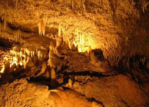
The team specifically mapped the Cathedral Cave. According to the National Showcaves of Wales, the Cathedral Cave is located below a local farm and starts as a small tunnel that opens up into a large cave, which is called the Dome of St. Paul's. This large structure in the Cathedral Cave as the Dome of St. Paul's has many stalactites, and even has numerous waterfalls that spill into underground lakes. The University of South Wales team was especially interested in scanning this part of the cave structure.
3D Laser Mapping reported a student may use the data to create digital versions of the site, but that option is still being looked into.